First Digital tool to develop Agriculture Hazard Mapping and Vulnerability Analysis (AHMVA) in Bangladesh
IUCN Bangladesh has initiated a project supported by the Food and Agriculture Organization of the United Nations (FAO) titled as “Building Resilience to Landslides through Land Stabilization, Promotion of Alternative Livelihoods and the Early Warning Systems in Cox’s Bazar District”. As part of this project, IUCN facilitated field survey in collaboration with expert team and Department of Agricultural Extension for the preparation of the Agriculture Hazard Mapping & Vulnerability Analysis (AHMVA) map. The maps are digitized in developing Bangladesh’s first digital tool to visualize agricultural hazard and vulnerability at block level as well as to take related preparatory measures.
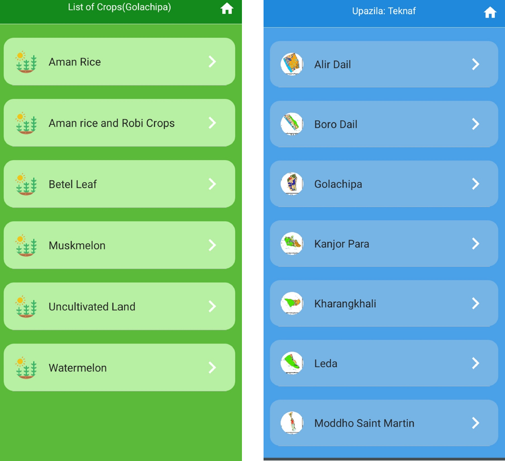
Photo: ©IUCN Bangladesh
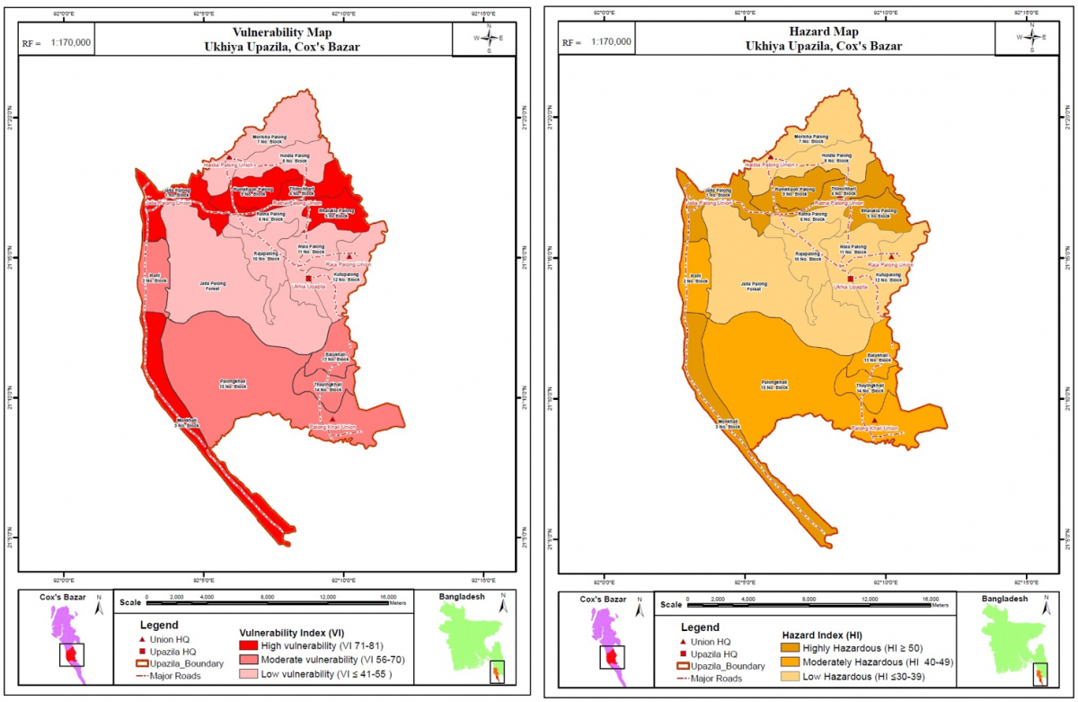
Photo: ©IUCN Bangladesh
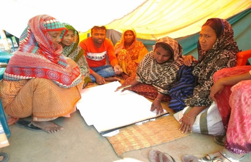
Cox’s Bazar is a vulnerable district in Southern Bangladesh where the level of food insecurity is alarming. The adverse impact of climate change with natural hazard wield rising pressure on the agriculture sector of Cox’s Bazar. In Ukhiya and Teknaf sub-districts of Cox’s Bazar district, an estimated one million people, including Rohingya refugees and host communities, live in areas at high risk of landslides and other natural hazards and disasters that have made agricultural activities highly challenging. The situation has created the necessity of an integrated and spatially specific Agriculture Hazard Mapping and Vulnerability Analysis. It has also been considered as important to understand and rank the agricultural crops in terms of their vulnerability to natural hazard. To address the situation, the Food and Agriculture Organization of the United Nations (FAO) initiated a project with support from the International Organization for Migration (IOM), funded by the USAID’s Bureau for Humanitarian Assistance. FAO has engaged IUCN to facilitate the base map collection and digitalization; consultation with Department of Agricultural Extension (DAE); Focus Group Discussion (FGD) with targeted communities and mapping; Field map validation; Soil sample collection; Map preparation for digital tool development; and organizing validation and consultation workshop to finalize Agriculture Hazard Mapping and Vulnerability Analysis (AHMVA) for Ukhiya and Teknaf.
AHMVA tool will ensure comprehensive decision about disaster risk reduction and climate-smart agriculture. This type of analysis is required not only for risk reduction and for mitigation, but for risk-informed sustainable yield and the execution of potential climate change mitigation actions. Hazard maps describe the specific location displaying to a specific type of hazard. Moreover, they depict the probability of the hazard's incidence, the frequency and its possible severity, which are based on historical data, and facts of past events. To understand the risks at micro level, for the base map collection and digitalization, each individual agricultural block maps of both Ukhiya and Teknaf were scanned and digitalized by ArcGIS software. Afterwards, Focus Group Discussion (FGD) was held in each agriculture block with respective stakeholders to collect data related to local hazard, agricultural crop variety, crop production and potential adaptation measures. Open Foris Mobile App were used as a survey tool of questionnaires and block wise maps were prepared from field and validated by Department of Agriculture Extension at Cox’s Bazar District. Concurrently, soil samples were collected form agricultural cropland to prepare crop suitability map and soil properties were analyzed by Bangladesh Agricultural University.
The tool developed as a mobile-based app named “Krishi Shurokkha” shows sub-district based individual crop suitability map, satellite view of specific crop area, crop production, hazard, and vulnerability map. It is considered as the first digital tool to envisage Agriculture Hazard Mapping and Vulnerability analysis in Bangladesh that can be further replicated in other parts of Bangladesh. With the heightened use of smartphones with Krishi Shurokkha app, farmers can take decision to choose individual crop suitability map and soil nutrients of a specific area. Moreover, they can oversee and discuss their problems to get a better solution. AHMVA tool will also benefit the Agriculture officers to monitor with more detailed database and automated technology. This digital tool supports in identifying the elements like crop populations, agricultural areas, livelihoods, services that are allied to hazards.
This app can be site-specific, cover administrative areas and subnational landscapes or it can be national and even regional in scope. With the achieved result from the AHMVA in Ukhiya and Teknaf, it is expected that the poor and vulnerable landslide-affected farming communities will be better protected from and more resilient to landslides and other hazards and disasters threatening their lives and livelihoods. The digital tool will enhance community awareness on safer agricultural practices and disaster shocks while disaster risk reduction in the context of agricultural production will be mainstreamed with the major stakeholders such as the Department of Agriculture Extension, Bangladesh Forest Department, and local government institutes.
Related content
CEESP News: by Rashed Al Mahmud Titumir * The people of the coastal area in Bangladesh…
IUCN has been working with UNHCR since 2018 to mitigate human-elephant conflict (HEC) around the…
The first-ever knowledge forum on the Meghna river basin, shared by Bangladesh and India, concluded…

Sign up for an IUCN newsletter